SouthCoastWX
82°F
New Bedford, MA, USA
Updated:  20-Jun-2025 4:11pm 
  Clear Temperature: 81.9°F Warmer 3.6°F than last hour.   3.6°F/hr Humidity: 35%Decreased 2.0% since last hour. Dew Point: 51.5°FIncreased 1.8°F since last hour. Wind: NNW  13.0 mph Gust: 22.2 mph Barometer: 29.88 inHgRising 0.07  inHg/hr  Rising Rapidly Rain Today: 0.00 in UV Index: 0  None

Navigation

  • Home
  • KMANEWBE28
    • Station Summary
    • Station Graphs
    • Live Gauges
  • Conditions
    • Nearby METAR Reports
    • NOAA NWS Hourly Roundups by Site
  • Radar and Satellite
    • Local Radar
    • US Ridge Radars
    • US Radar and Satellite
    • GOES16 Satellite Loops EAST
    • GOES17 Satellite Loops WEST
  • Forecast & Advisories
    • 7 Day Forecast
    • Advisories
    • Nationwide Advisory Map
    • UV Index Forecast
  • NWS Tools
    • Maps and Charts
      • 3 Day Forecast Charts
    • Severe
      • Enhanced Hazardous Weather Outlook
      • Hazardous Weather Outlook Text
    • Forecast Models
      • Quantitative Precipitation Forecast Loops
      • US 24 Hour Forecasts/Analyses
      • WPC high-resolution medium-range forecast
      • 10 Day Jet Stream Forecasts
      • Short Range Forecast Loop
    • Forecaster Discussion
  • NOAA Radio
    • Listen Now
  • Climate
    • Climate Prediction Center Outlook and Drought Monitor
  • Tropical
    • Hurricane Center
  • Winter
    • Snow or Ice Accumulation Potential
    • Winter Storm Severity Indices
    • NWS Winter 3 Day Surface Lows
    • US Contiguous 48 States Snow Analyses
    • Probability of Snow
  • Marine
    • NB Hurricane Barrier Tides
    • Mass River Observations LINK
    • NE Marine Traffic
  • Air Quality
    • Air Quality Index
  • Almanac
    • Sun/Moon Almanac
    • Earthquake activity
  • KCTOXFOR34
  • Links
  • Photos - Link
  • Flu - Link
  • About
  • Status
  • Website Map

External Links

  • Weather Underground
  • WXforum.net

Alerts

New Bedford
  Details for New Bedford Extreme Heat Watch
Marion/Wareham
  Details for Marion/Wareham Extreme Heat Watch


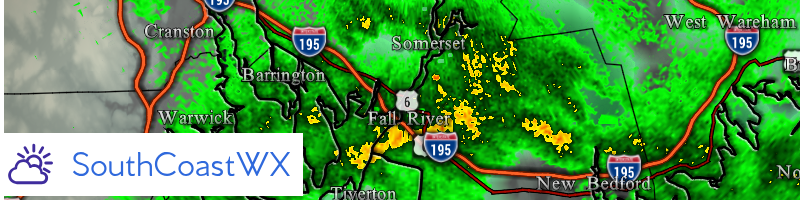
WPC high-resolution medium-range forecast display

  — 

Forecast Day

3
3 ½
4
4 ½
5
5 ½
6
6 ½
7
7 ½

Filled background

Temperature anomaly (°F)
Td (°F)
Cloud cover (%)
NDFD Wx type
WPC Wx type
Simple Wx type*
12-hr PoP (%)
PMSL ensemble spread (mb)

Overlays

Fronts (12Z only) and isobars

Wind Barbs
Station Values

Isotherms 0° 32° 100°

Full Size Maps

Click for 3 Day Front Forecast Charts
Maps and Data Courtesy of NOAA NWS Weather Prediction Center.
Script by SE Lincoln Weather.

Top | Contact Us
© 2025, Southcoast Weather | AmbientWeather.net Network | Valid XHTML 1.0 | Valid CSS

Never base important decisions on this or any weather information obtained from the Internet.