SouthCoastWX
49°F
New Bedford, MA, USA
Updated:  10-Dec-2023 6:22am 
  Overcast Temperature: 48.6°F Warmer 0.9°F than last hour.   0.9°F/hr Humidity: 92%  Dew Point: 46.4°FIncreased 0.9°F since last hour. Wind: SSW  0.0 mph Gust: 0.0 mph Barometer: 30.14 inHg   Steady Rain Today: 0.00 in UV Index: 0  None

Navigation

  • Home
  • KMANEWBE28
    • Station Summary
    • Station Graphs
    • Live Gauges
  • Conditions
    • Nearby METAR Reports
    • NOAA NWS Hourly Roundups by Site
  • Radar and Satellite
    • Local Radar
    • US Ridge Radars
    • US Radar and Satellite
    • GOES16 Satellite Loops EAST
    • GOES17 Satellite Loops WEST
  • Forecast & Advisories
    • 7 Day Forecast
    • Advisories
    • Nationwide Advisory Map
    • UV Index Forecast
  • NWS Tools
    • Maps and Charts
      • 3 Day Forecast Charts
    • Severe
      • Enhanced Hazardous Weather Outlook
      • Hazardous Weather Outlook Text
    • Forecast Models
      • Quantitative Precipitation Forecast Loops
      • US 24 Hour Forecasts/Analyses
      • WPC high-resolution medium-range forecast
      • 10 Day Jet Stream Forecasts
      • Short Range Forecast Loop
    • Forecaster Discussion
  • NOAA Radio
    • Listen Now
  • Climate
    • Climate Prediction Center Outlook and Drought Monitor
  • Tropical
    • Hurricane Center
  • Winter
    • Snow or Ice Accumulation Potential
    • Winter Storm Severity Indices
    • NWS Winter 3 Day Surface Lows
    • US Contiguous 48 States Snow Analyses
    • Probability of Snow
  • Marine
    • NB Hurricane Barrier Tides
    • Mass River Observations LINK
    • NE Marine Traffic
  • Air Quality
    • Air Quality Index
  • Almanac
    • Sun/Moon Almanac
    • Earthquake activity
  • KCTOXFOR34
  • Links
  • Photos - Link
  • Flu - Link
  • About
  • Status
  • Website Map

External Links

  • Weather Underground
  • WXforum.net

Alerts

New Bedford
  Details for New Bedford High Wind Warning  +3 additional alerts
Marion/Wareham
  Details for Marion/Wareham High Wind Warning  +2 additional alerts


US Contiguous 48 States Snow Analyses


Choose Date:
New Maps Are Posted After 6am Chicago Time
Year:   Month:   Day:  

Region Selectors

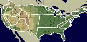
Imagemap to select NSA subregion Northwest Northern Rockies Intermountains Great Basin Sierra Nevada Western Coastal Southwest Central Rockies Western Plains Upper Midwest Midwest Northern Great Lakes South Southern Appalachia Southern Great Lakes Allegheny Front Eastern Coastal Northeast National
Click map area to select region
or choose from dropdown

National Snow Analyses for December 9, 2023

Snow Depth | Snow Water Equivalent | 24 Hr. Average Snowpack Temperature
24 Hr. Change Snow Water Equivalent | 24 Hr. Total Scaled Snow Precipitation
24 Hr. Snow Melt | 24 Hr. Blowing Snow Sublimation
24 Hr. Surface Sublimation | 24 Hr. Non-Snow Precipitation
(Mouse Over a Link to Display Map)
nsm_depth Click to Display Animation: Season | Two Weeks | One Day
nsm_swe Click to Display Animation: Season | Two Weeks | One Day
nsm_ave_temp_24hr Click to Display Animation: Season | Two Weeks | One Day
nsm_swe_change_24hr Click to Display Animation: Season | Two Weeks | One Day
ruc_snow_precip_24hr Click to Display Animation: Season | Two Weeks | One Day
nsm_melt_24hr Click to Display Animation: Season | Two Weeks | One Day
nsm_blowing_snow_sub_24hr Click to Display Animation: Season | Two Weeks | One Day
nsm_surface_sub_24hr Click to Display Animation: Season | Two Weeks | One Day
ruc_nonsnow_precip_24hr Click to Display Animation: Season | Two Weeks | One Day

Maps and Data Courtesy of NOAA NWS National Operational Hydrologic Remote Sensing Center
National Snow Analyses where past seasona from 2003 and Interactive Maps are available.

Script by SE Lincoln Weather.
Top | Contact Us
© 2023, Southcoast Weather | AmbientWeather.net Network | Valid XHTML 1.0 | Valid CSS

Never base important decisions on this or any weather information obtained from the Internet.