SouthCoastWX
35°F
New Bedford, MA, USA
Updated:  13-Mar-2026 9:32pm 
  Mostly cloudy Temperature: 35.2°F     0.0°F/hr Humidity: 58%Increased 3.0% since last hour. Dew Point: 21.9°FIncreased 1.2°F since last hour. Wind: SSW  0.0 mph Gust: 0.0 mph Barometer: 30.03 inHg   Steady Rain Today: 0.00 in UV Index: 0  None

Navigation

  • Home
  • KMANEWBE28
    • Station Summary
    • Station Graphs
    • Live Gauges
  • Conditions
    • Nearby METAR Reports
    • NOAA NWS Hourly Roundups by Site
  • Radar and Satellite
    • Local Radar
    • US Ridge Radars
    • US Radar and Satellite
    • GOES16 Satellite Loops EAST
    • GOES17 Satellite Loops WEST
  • Forecast & Advisories
    • 7 Day Forecast
    • Advisories
    • Nationwide Advisory Map
    • UV Index Forecast
  • NWS Tools
    • Maps and Charts
      • 3 Day Forecast Charts
    • Severe
      • Enhanced Hazardous Weather Outlook
      • Hazardous Weather Outlook Text
    • Forecast Models
      • Quantitative Precipitation Forecast Loops
      • US 24 Hour Forecasts/Analyses
      • WPC high-resolution medium-range forecast
      • 10 Day Jet Stream Forecasts
      • Short Range Forecast Loop
    • Forecaster Discussion
  • NOAA Radio
    • Listen Now
  • Climate
    • Climate Prediction Center Outlook and Drought Monitor
  • Tropical
    • Hurricane Center
  • Winter
    • Snow or Ice Accumulation Potential
    • Winter Storm Severity Indices
    • NWS Winter 3 Day Surface Lows
    • US Contiguous 48 States Snow Analyses
    • Probability of Snow
  • Marine
    • NB Hurricane Barrier Tides
    • Mass River Observations LINK
    • NE Marine Traffic
  • Air Quality
    • Air Quality Index
  • Almanac
    • Sun/Moon Almanac
    • Earthquake activity
  • KCTOXFOR34
  • Links
  • Photos - Link
  • Flu - Link
  • About
  • Status
  • Website Map

External Links

  • Weather Underground
  • WXforum.net

Alerts


No alerts

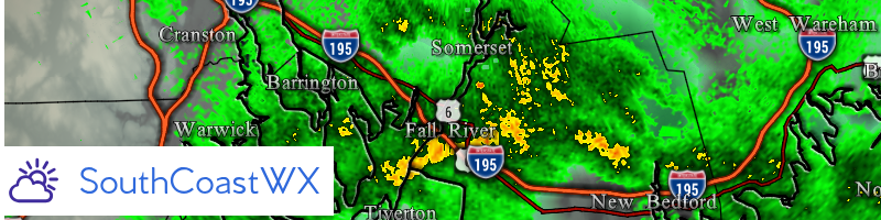
National Weather Service Forecast for: New Bedford, MA
Issued by: National Weather Service Boston / Norton, MA
Updated: Fri, 13-Mar-2026 2:45pm EDT

New Bedford
 
  Saturday

Saturday: Mostly Sunny
Mostly Sunny
Sunday

Sunday: Partly Sunny
Partly Sunny
Monday

Monday: Rain
Rain
Tuesday

Tuesday: Chance Rain And Snow
Chance Rain And Snow
Wednesday

Wednesday: Mostly Sunny
Mostly Sunny
Thursday

Thursday: Partly Sunny
Partly Sunny
Friday

Friday: Partly Sunny
Partly Sunny
  Hi 47 °F Hi 44 °F Hi 56 °F Hi 47 °F Hi 38 °F Hi 42 °F Hi 45 °F
 
Tonight

Tonight: Mostly Cloudy then Rain Showers Likely
Mostly Cloudy then Rain Showers Likely
Saturday
Night
Saturday Night: Mostly Clear
Mostly Clear
Sunday
Night
Sunday Night: Mostly Cloudy then Slight Chance Light Rain
Mostly Cloudy then Slight Chance Light Rain
Monday
Night
Monday Night: Rain
Rain
Tuesday
Night
Tuesday Night: Mostly Clear
Mostly Clear
Wednesday
Night
Wednesday Night: Mostly Cloudy
Mostly Cloudy
Thursday
Night
Thursday Night: Partly Cloudy
Partly Cloudy
 
Lo 33 °F Lo 28 °F Lo 34 °F Lo 39 °F Lo 21 °F Lo 26 °F Lo 30 °F  


Tonight
 
Rain showers likely between midnight and 3am. Mostly cloudy. Low around 33, with temperatures rising to around 39 overnight. South wind 9 to 15 mph, with gusts as high as 30 mph. Chance of precipitation is 70%. New rainfall amounts less than a tenth of an inch possible.
Saturday
 
Mostly sunny, with a high near 47. West wind 15 to 21 mph, with gusts as high as 39 mph.
Saturday Night
 
Mostly clear, with a low around 28. West wind 5 to 15 mph, with gusts as high as 30 mph.
Sunday
 
Partly sunny, with a high near 44. Northeast wind 2 to 8 mph.
Sunday Night
 
A slight chance of rain after 3am. Mostly cloudy, with a low around 34. Southeast wind 6 to 12 mph, with gusts as high as 24 mph. Chance of precipitation is 20%.
Monday
 
Rain before 11am, then rain and isolated thunderstorms. Cloudy, with a high near 56. Southeast wind 13 to 20 mph, with gusts as high as 36 mph. Chance of precipitation is 100%.
Monday Night
 
Rain and a slight chance of thunderstorms. Cloudy, with a low around 39. South wind 18 to 23 mph, with gusts as high as 40 mph. Chance of precipitation is 100%.
Tuesday
 
Rain likely before 11am, then a chance of rain and snow between 11am and 4pm. Partly sunny, with a high near 47. Southwest wind 15 to 18 mph, with gusts as high as 32 mph. Chance of precipitation is 70%.
Tuesday Night
 
Mostly clear, with a low around 21. West wind 8 to 16 mph, with gusts as high as 26 mph.
Wednesday
 
Mostly sunny, with a high near 38. West wind around 8 mph.
Wednesday Night
 
Mostly cloudy, with a low around 26. South wind 2 to 6 mph.
Thursday
 
Partly sunny, with a high near 42. South wind 2 to 9 mph.
Thursday Night
 
Partly cloudy, with a low around 30. Southwest wind 3 to 7 mph.
Friday
 
Partly sunny, with a high near 45. West wind 5 to 9 mph.


Forecast from NOAA-NWS for New Bedford, MA.

Top | Contact Us
© 2026, Southcoast Weather | AmbientWeather.net Network | Valid XHTML 1.0 | Valid CSS

Never base important decisions on this or any weather information obtained from the Internet.