NWS Forecaster Discussion
BOX
Area Forecast Discussion National Weather Service Boston/Norton MA.
675
FXUS61 KBOX 291852
AFDBOX
Area Forecast Discussion
National Weather Service Boston/Norton MA
252 PM EDT Wed Jul 29 2026
.WHAT HAS CHANGED...
No significant changes.
&&
.KEY MESSAGES...
- Heavy rain at times continues into this evening, leading to
the potential street and flash flooding, especially across
western New England.
* Light showers linger into Friday, with improving conditions for
the upcoming weekend.
* Unsettled weather returns late Sunday night into Monday,
followed by drier conditions Tuesday.
&&
.DISCUSSION...
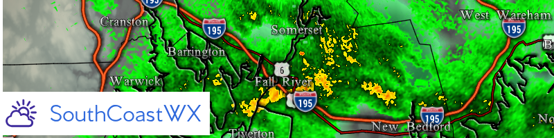
KEY MESSAGE 1...Periods of heavy rainfall continue into Wednesday
evening, leading to potential street and flash flooding, especially
across western portions of MA.
High amplitude vertically stacked low over southeast NYS this
afternoon, with a deep Atlantic moisture plume pivoting cyclonically
across New England. A very atypical system for late July, with cool
season jet dynamics (negative tilt mid/upper trough) via strong
cyclonically curved flow aloft, combined with 35-45kt of moist low
level SE jet providing upslope enhancement, acting on a warm season
moisture plume up to 150% of normal. This will continue to support
the ongoing forecast of potential flash flooding, with the greatest
threat across the eastern slopes of the Berkshires.
As the low level jet pivots and lifts north into NH/VT, the heaviest
rainfall shifts north into NH/ME tonight. This will result in lower
rainfall rates and more of a stratiform rain across MA/RI/CT
tonight.
Thursday the vertically stacked low aloft drifts over SNE, with
surface low over the Gulf of Maine. Moist cyclonic flow aloft
continues, yielding overcast conditions along with scattered
showers. -10C to -12C at 500 mb will provide some elevated
instability and some of the CAMS indicate isolated to scattered
heavy showers with embedded thunder across CT/RI and southeast MA.
Moisture plume also across this area with PWATs up to 1.5 inches.
Thus, a low risk for isolated flash flooding across this region Thu
PM. As for temperatures, persistent easterly flow and thick
cloudcover/rainfall will depress high temperatures into the low to
mid 70s Thursday.
Drying trend Thu night as vertically stacked low lifts northeast
into Maine and the Maritimes. However, low clouds, drizzle and fog
may linger.
KEY MESSAGE 2...Light showers linger into Friday, with improving
conditions for the upcoming weekend.
The aforementioned vertically stacked low pressure system begins to
lift northeast away from southern New England Friday morning. Friday
serves as a transition day as the departing low gives way to subtle
mid-level ridging and weak surface high pressure heading into the
weekend. While periods of light rain and drizzle remain possible
Friday, the overall trend is toward improving conditions.
Even as the primary low departs, its trailing mid-level trough will
linger over the region, allowing weak shortwave energy to rotate
through southern New England. With PWATs remaining around 1.3 inches
and the lowest several thousand feet of the atmosphere remaining
saturated, scattered light showers or areas of drizzle remain
possible. Winds gradually shift from onshore to northerly and
eventually north-northwesterly by late Friday. Combined with
abundant cloud cover, highs will remain below normal, generally in
the middle 70s to around 80.
The weekend will not be as sunny as last weekend, but it should be
considerably drier. A mix of clouds and sunshine is expected both
Saturday and Sunday. PWATs remain near climatological normals
Saturday before increasing to around 1.2 to 1.5 standard deviations
above normal by Sunday afternoon ahead of the next system. While
most locations should remain dry, a passing shortwave could produce
an isolated afternoon shower or even a rumble of thunder. Overall,
subtle mid-level ridging and developing south to southwest return
flow will support a warming trend, with highs returning to
seasonable levels in the lower to middle 80s both Saturday and
Sunday.
KEY MESSAGE 3...Unsettled weather returns late Sunday night into
Monday, followed by drier conditions Tuesday.
Attention then turns to the next system, as a mid-level trough and
associated cold front approach late Sunday night into Monday. While
uncertainty remains regarding the exact timing and evolution of the
system, this currently appears to be the next opportunity for
widespread rainfall.
Ensemble guidance indicates PWATs will be slightly above normal,
with most solutions favoring a progressive system that should limit
the flash flood threat. Current ensemble probabilities for 24-hour
rainfall amounts exceeding one-half inch range from 20 to 40
percent. High pressure is then expected to build into the region
Tuesday, bringing a return to drier conditions, although confidence
in the timing of the frontal passage remains lower given the 5 to 6
day forecast horizon.
&&
.AVIATION /18Z WEDNESDAY THROUGH MONDAY/...
Forecaster Confidence Levels...
Low - less than 30 percent.
Moderate - 30 to 60 percent.
High - greater than 60 percent.
18z TAF update...
This afternoon and Tonight...High confidence on trends.
Bands of moderate to heavy rain will continue to impact terminals
this afternoon. However, with dry slot moving across CT and
eventually into RI and eastern MA, heavy rain bands will transition
to more of stratiform light rain/drizzle later this afternoon and
into tonight. Nonetheless, any remaining VFR vsbys will transition
to MVFR and cigs will transition to IFR/LIFR.
East surface winds will remain gusty along the coastal terminals, up
to 25 kt at times through about 03z, then becoming northeast and
slackening a bit thereafter. Marginal LLWS will continue until about
00z-03z, as ESE low level jet traverses the region. Not expecting
any TSRA, as this is more of a cool-season Nor`easter than a summer-
time rain event.
Thursday...Moderate confidence.
Vertically stacked low is very slow to move, therefore LIFR/IFR cigs
with MVFR vsbys in areas of light rain/drizzle and fog, only slowly
improve to IFR/MVFR cigs and MVFR/VFR vsbys. Low risk for a few
heavy showers and isolated TSRA across RI and southeast MA terminals
Thu PM. Light surface winds with broad area of low pressure over the
region.
Thursday Night...Moderate confidence.
Widespread IFR and lower end MVFR in lingering spotty light
showers/drizzle and areas of fog. N winds remaining generally below
10 kt.
KBOS Terminal...High confidence on trends. Marginal LLWS until about
03z, with east to southeast winds up to 45 kt at 2kft. East surface
winds gusting up to 25 kt at times, then slackening a bit after 03z
as winds turn to the NE. MVFR/IFR cigs at 18z in SHRA will continue
to trend toward IFR/LIFR this evening and overnight, along with VFR
vsby trending to MVFR/IFR.
KBDL Terminal...High confidence in trends. Steady rains this Wed AM
have transitioned to more showery this afternoon, providing more
fluctuations in cigs and vsbys. However, overall trends will be
down to MVFR vsbys and IFR cigs.
Outlook /Thursday Night through Monday/...
Friday: VFR. Slight chance SHRA.
Friday Night through Saturday Night: VFR.
Sunday: VFR. Chance SHRA, slight chance TSRA.
Sunday Night through Monday: Mainly VFR, with local IFR
possible. Chance SHRA, slight chance TSRA.
&&
.MARINE...
Forecaster Confidence Levels...
Low - less than 30 percent.
Moderate - 30 to 60 percent.
High - greater than 60 percent.
Surface low over western Long Island Wed afternoon, will continue to
yield ESE winds 20 to 30 kt. As this low slowly moves east, the
strongest winds will lift north into NH/ME tonight. However, seas
will remain rough. Heavy showers at times will limit vsby at times.
During Thu and Thu night, the low over the Gulf of ME will slowly
continue to move NE. Light N-NE winds with seas slowly subsiding.
Vsby 1-3NM at times in areas of fog and showers.
Outlook /Thursday Night through Monday/...
Friday through Friday Night: Winds less than 25 kt. Seas up to
5 ft.
Saturday: Winds less than 25 kt. Seas locally approaching 5 ft.
Saturday Night through Sunday: Winds less than 25 kt.
Sunday Night: Winds less than 25 kt. Chance of rain showers.
Monday: Winds less than 25 kt. Areas of rough seas. Chance of
rain showers.
&&
.BOX WATCHES/WARNINGS/ADVISORIES...
CT...Flood Watch until 8 PM EDT this evening for CTZ002>004.
MA...Flood Watch until 8 PM EDT this evening for MAZ002>004-008>012.
RI...Flood Watch until 8 PM EDT this evening for RIZ001-002.
MARINE...Small Craft Advisory until 8 PM EDT this evening for
ANZ230>237-251.
Small Craft Advisory until 8 PM EDT Thursday for ANZ250.
Small Craft Advisory until 2 PM EDT Thursday for ANZ254>256.
&&
$$
DISCUSSION...Dooley/Nocera
AVIATION...Dooley/Nocera
MARINE...Dooley/Nocera